End of Chapter 1: 2012
We arrived in SLC on Sunday, April 8, and proceeded to Pocatello on Tuesday, April 10. We have been busy ever since completing our taxes and mucking out the trailer and simply catching up with all the things we've ignored for two months. We will store the trailer for a while and head to the cabin as soon as we finish what we need to get done in Pocatello. So this chapter in our "Big Adventure" has come to an end but we will update the blog periodically to let everyone know about interesting events in our retirement.
Our next trip with the trailer in tow is planned for Labor Day when we will head for the Seattle area to visit Chris and family. We will take Grandma Shirley so she can see the granddaughters - Shirley will stay with Chris and Kristen and we will park the trailer in a nearby RV park. We're sure that there will be some fun images to post on this blog during that trip. So check back occasionally for updates!
A footnote: As of today there have been 767 page views of our blog since we started it two months ago. So thanks for the interest and for the comments you have made!
Thursday, April 12, 2012
Saturday, April 7, 2012
This morning we sought out a Forest Service trail outside of Bryce Canyon so we could take Abby for a hike unleashed. Following the suggestion of a forest ranger we hiked in Red Canyon along Pink Ledges and Hoodoo trails.


Hoodoos everywhere! According to forest service literature hoodoos are "columns, pinnacles or pillars of rock that have variable thickness and a totem pole shaped appearance."


We had a great time enjoying the scenery and fresh air (not as cold as yesterday but still chilly and breezy).


We returned to the trailer for some lunch and then headed into Bryce Canyon National Park to the only trail that is dog friendly.

Some beautiful sights but Abby gets impatient when we stop and gawk because she is tethered to us.

After that we headed back out of the park and into forest land to Pine Lake. We saw a 1930s photo of Rubin "Ruby" Syrett (the guy who developed his homestead into the current massive resort in which we are staying) on horseback at Pine Lake. Sharon saw a highway sign that pointed the direction so we followed it. We drove through some mud and melting snow but were rewarded with some beautiful views. And Abby got to run untethered!


When we returned to our trailer Sharon had a phone message from Chris. Apparently Kristen just landed a job and starts the same day as Chris's new job! Congratulations - a new chapter in their lives!
Tomorrow morning we pack up and head for Salt Lake, then off to Pocatello. It is hard to imagine that we have been on the road for almost two months. Time does fly by when your having fun!
Friday, April 6, 2012
As planned, we toured Bryce Canyon National Park today. The sky was crystal clear but it was windy and cold (mid to upper 30s) so the breeze had a real bite to it. We visited several overlooks and did one short hike up to an overlook (all at 8500' to 9200' elevation) and saw some of the most complex and intricate landscape we have ever seen. In the words of Ebeneezer Bryce who homesteaded directly below the cliffs "it's a hell of a place to lose a cow." Remember you can click on the first picture and view them all full screen.


We both agree that Bryce is more interesting and enjoyable than the Grand Canyon, both because the various viewpoints overlook different scenery (at the Grand Canyon they all viewed the same scenery - just from slightly different angles so it got boring) and because we didn't have to fight the crowds to get a glimpse.
Tomorrow we are going to take a hike on a longer trail where dogs are allowed so stay tuned for more pics.
Yesterday we drove from Grand Canyon, AZ, to Bryce Canyon, UT. The five-hour drive was interesting but tiring because of the gusty winds pushing the trailer around. We set up at Ruby's Inn RV Park just a couple of miles from the park entrance. It is an interesting and beautiful place, and it is an important part in the history of national parks in Utah's (to read about it click on the Ruby's Inn link).

Today we will check out Bryce Canyon and plan our next couple of days of hikes and sightseeing.

Today is cold and windy, (but sunny) so we probably won't spend a lot of time today out of the car, visitor center, or trailer. However the weather is supposed to improve tomorrow. One problem with camping in a beautiful campground like this is that it is in a mature stand of Ponderosa pines so we haven't been able to get satellite TV reception (because we don't have an unobstructed view of the southern sky) - whatever will we do?
Wednesday, April 4, 2012
As we mentioned yesterday, we are tired of large crowds so this morning we drove to the Red Butte trailhead on forest service land 6 or 8 miles south of our RV park.

The butte (elevation at the top is 7326') rises over 900 feet above the surrounding plateau and the trail up it is about 1.25 miles long. It was a beautiful sunny cool day so the hike was great. And the best thing is we had it all to ourselves.

All over the flat top is a light scatter of prehistoric stone waste flakes (pink to orange chert and an occasional obsidian flake) left over from making and repairing stone tools.

The Havasupai say it is a sacred place and their name for it translates as "clinched fist mountain."

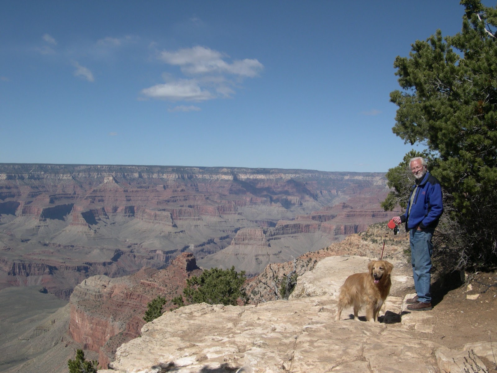
The 360 degree views are beautiful - to the north the north rim of the Grand Canyon can be seen (barely visible on the horizon behind Sharon and Abby in the photo above), and to the southeast the snow covered San Francisco Mountains (which contains a major source of obsidian used by prehistoric folks).

This afternoon we are puttering around the trailer relaxing and stowing most things so we can leave first thing in the morning on our way to Bryce Canyon (a 250 mile drive). Hopefully we will beat the hordes of tourists entering the park.

The butte (elevation at the top is 7326') rises over 900 feet above the surrounding plateau and the trail up it is about 1.25 miles long. It was a beautiful sunny cool day so the hike was great. And the best thing is we had it all to ourselves.

All over the flat top is a light scatter of prehistoric stone waste flakes (pink to orange chert and an occasional obsidian flake) left over from making and repairing stone tools.

The Havasupai say it is a sacred place and their name for it translates as "clinched fist mountain."

The 360 degree views are beautiful - to the north the north rim of the Grand Canyon can be seen (barely visible on the horizon behind Sharon and Abby in the photo above), and to the southeast the snow covered San Francisco Mountains (which contains a major source of obsidian used by prehistoric folks).

This afternoon we are puttering around the trailer relaxing and stowing most things so we can leave first thing in the morning on our way to Bryce Canyon (a 250 mile drive). Hopefully we will beat the hordes of tourists entering the park.
Tuesday, April 3, 2012
After a leisurely morning we headed into GCNP around 10:30, and we were surprised. Traffic was backed up for about a half mile at the five entry gates. It took us about a half hour inch-by-inch to enter the park. We avoided the Village area which is the real concentration of people and drove along the Desert View Drive to the Desert View Visitor's Center near the east entrance to the park (not the main visitor's center that we couldn't get into yesterday).

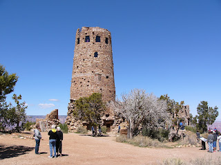
There were plenty of available parking spots so we walked around some and climbed to the top of the Watchtower, a 1930s construction designed by the famous architect Mary Colter mimicking a Native American ruin.
Views were beautiful and it has been a clear cool day - excellent for walking around so we stopped at a few lookout points on our way back.

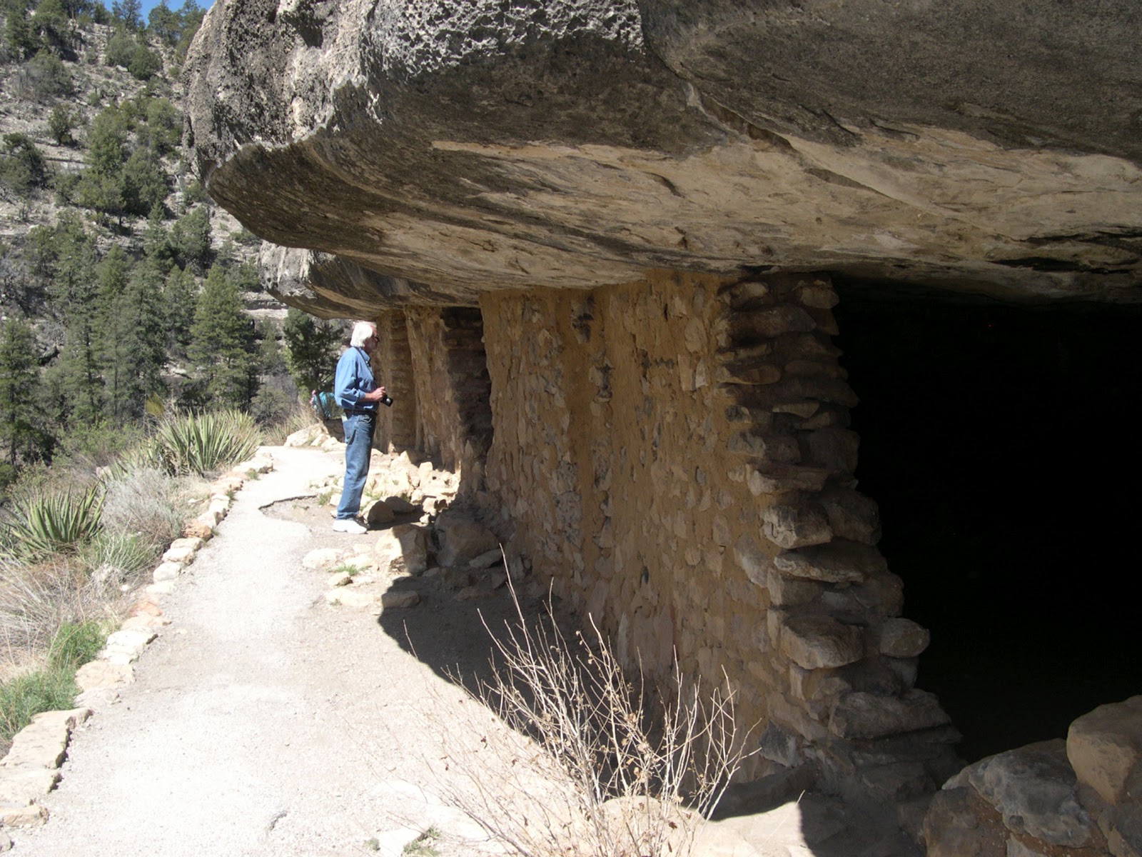
Some overlooks were so crowded that there were no parking spots - just a line of cars waiting for someone to leave, so we avoided those. We stopped at the Tusayan Ruin and Museum and there were very few people there. I guess most folks go to the Grand Canyon to see the canyon and rocks, not the prehistory of human use of the canyon environments.

The Tusayan Ruin is one of over 4000 sites known in the Park. It was built around A.D. 1185 and probably housed about 20 to 30 people. They gathered wild foods and grew crops, which is rather amazing because it is about 7300' in elevation. This was during a period of global warming named by scientists the Medieval Warm Period. The small community was short lived because by 1250 the world was entering the Little Ice Age and the frost-free growing season became too short for crops at that altitude.

Continuing on our way we stopped at a picnic area for lunch and all the tables were being used so we found a nice log.

It was a beautiful day but we are "peopled out" so we left the park and don't plan to return tomorrow. We stopped by the Kaibab National Forest office and picked up some info and maps about hikes in the forest, so that is what we will do tomorrow. Because of the congestion we have encountered in the Park we plan to get up early on Thursday and hopefully beat the hordes through the Park on our way to Bryce Canyon, Utah.

There were plenty of available parking spots so we walked around some and climbed to the top of the Watchtower, a 1930s construction designed by the famous architect Mary Colter mimicking a Native American ruin.

Views were beautiful and it has been a clear cool day - excellent for walking around so we stopped at a few lookout points on our way back.

Some overlooks were so crowded that there were no parking spots - just a line of cars waiting for someone to leave, so we avoided those. We stopped at the Tusayan Ruin and Museum and there were very few people there. I guess most folks go to the Grand Canyon to see the canyon and rocks, not the prehistory of human use of the canyon environments.

The Tusayan Ruin is one of over 4000 sites known in the Park. It was built around A.D. 1185 and probably housed about 20 to 30 people. They gathered wild foods and grew crops, which is rather amazing because it is about 7300' in elevation. This was during a period of global warming named by scientists the Medieval Warm Period. The small community was short lived because by 1250 the world was entering the Little Ice Age and the frost-free growing season became too short for crops at that altitude.

Continuing on our way we stopped at a picnic area for lunch and all the tables were being used so we found a nice log.

It was a beautiful day but we are "peopled out" so we left the park and don't plan to return tomorrow. We stopped by the Kaibab National Forest office and picked up some info and maps about hikes in the forest, so that is what we will do tomorrow. Because of the congestion we have encountered in the Park we plan to get up early on Thursday and hopefully beat the hordes through the Park on our way to Bryce Canyon, Utah.
Monday, April 2, 2012
Today we moved the short distance from Williams to Tusayan, AZ which is located adjacent to the south entrance of Grand Canyon National Park.

After setting up our trailer we drove into the park and were flabbergasted. We entered the visitor's center parking lots and there was not a single spot available. Cars were backed up waiting for anyone to pull out - it was a mess. So we drove along Desert View Drive and stopped at a few overlooks (the ones that had parking slots available).

Dogs are allowed on the rim trails so Abby got some fresh air and saw some awesome views.

She even got to meet Smokey the Bear!

Tomorrow we plan to visit the Tusayan Ruins Museum and take a few short hikes around some overlooks; and on Wednesday we will probably take a long hike along the rim trail that is only accessible by foot or shuttle bus (but no dogs are allowed on the bus).

After setting up our trailer we drove into the park and were flabbergasted. We entered the visitor's center parking lots and there was not a single spot available. Cars were backed up waiting for anyone to pull out - it was a mess. So we drove along Desert View Drive and stopped at a few overlooks (the ones that had parking slots available).

Dogs are allowed on the rim trails so Abby got some fresh air and saw some awesome views.
She even got to meet Smokey the Bear!

Tomorrow we plan to visit the Tusayan Ruins Museum and take a few short hikes around some overlooks; and on Wednesday we will probably take a long hike along the rim trail that is only accessible by foot or shuttle bus (but no dogs are allowed on the bus).
Sunday, April 1, 2012
Yesterday morning we drove to the Flagstaff area and visited Walnut Canyon National Monument. The mesa-top visitor's center is about 6700' in elevation and the canyon cuts down into the mesa about 350'.

It is a beautiful canyon and every nook and cranny in the cliff walls are filled in with prehistoric houses and storage rooms.

More than 80 structures built between A.D. 1100-1250 can be seen during the hike although there are many more outside of the area accessible by the public.


There are also dozens of residence and storage structures built on the mesa top near their crop fields (the canyon bottom is way to narrow to grow any crops). However, the canyon hosts over 375 species of wild plants, many of which are edible (including the Arizona black walnut) and possibly explains the canyon's population density.

After hiking the canyon, which was tiring because of all the vertical along the trail, we drove up through Sunset Crater National Monument. It erupted sometime between A.D. 1065 to 1085, so there were probably a lot of people living in the area that were blanketed with volcanic ash. Interestingly, the ash dramatically improved the local soil fertility and there was a subsequent influx of people. This story is fundamental to our afternoon stop, Wupatki National Monument.

Construction of the Wupatki Pueblo began around A.D. 500 but rapidly expanded during the century after the Sunset Crater eruption as at several other smaller pueblos in the vicinity. At its peak Wupatki contained 100 rooms and a Mesoamerican style ball court (and there were other Mesoamerican items such as scarlet macaw feathers).

According to the park archaeologists, Wupatki was built by the Sinagua people (the same culture who built Tuzigoot, Montezuma Castle, and our RV park site in Cottonwood). However, the influx of approximately 2000 people into the region after the Sunset Crater eruption brought adjacent cultures together. Wupatki ended up as an international community with a remarkable blend of foreign attributes (architectural styles, pottery types, copper bells, etc.).

Like so many other pueblos in the region, Wupatki was abandoned by A.D. 1250 possibly because of a few decades of drought. Like everywhere in the Southwest small groups began gathering together in major river valleys and started building large pueblos and extensive canal systems (like at Casa Grande which we reported on early in our adventure blog).
Today we are lounging around the trailer reading and writing and watching some TV. A storm front is moving through with gusty winds, and there is a possibility of a little rain. Tomorrow we move to the Grand Canyon for a few days, and then off to Bryce Canyon for a few days. We will stop in SLC next weekend on our way to Pocatello (estimated time of arrival is Tuesday, April 10+).

It is a beautiful canyon and every nook and cranny in the cliff walls are filled in with prehistoric houses and storage rooms.

More than 80 structures built between A.D. 1100-1250 can be seen during the hike although there are many more outside of the area accessible by the public.

There are also dozens of residence and storage structures built on the mesa top near their crop fields (the canyon bottom is way to narrow to grow any crops). However, the canyon hosts over 375 species of wild plants, many of which are edible (including the Arizona black walnut) and possibly explains the canyon's population density.

After hiking the canyon, which was tiring because of all the vertical along the trail, we drove up through Sunset Crater National Monument. It erupted sometime between A.D. 1065 to 1085, so there were probably a lot of people living in the area that were blanketed with volcanic ash. Interestingly, the ash dramatically improved the local soil fertility and there was a subsequent influx of people. This story is fundamental to our afternoon stop, Wupatki National Monument.

Construction of the Wupatki Pueblo began around A.D. 500 but rapidly expanded during the century after the Sunset Crater eruption as at several other smaller pueblos in the vicinity. At its peak Wupatki contained 100 rooms and a Mesoamerican style ball court (and there were other Mesoamerican items such as scarlet macaw feathers).

According to the park archaeologists, Wupatki was built by the Sinagua people (the same culture who built Tuzigoot, Montezuma Castle, and our RV park site in Cottonwood). However, the influx of approximately 2000 people into the region after the Sunset Crater eruption brought adjacent cultures together. Wupatki ended up as an international community with a remarkable blend of foreign attributes (architectural styles, pottery types, copper bells, etc.).

Like so many other pueblos in the region, Wupatki was abandoned by A.D. 1250 possibly because of a few decades of drought. Like everywhere in the Southwest small groups began gathering together in major river valleys and started building large pueblos and extensive canal systems (like at Casa Grande which we reported on early in our adventure blog).
Today we are lounging around the trailer reading and writing and watching some TV. A storm front is moving through with gusty winds, and there is a possibility of a little rain. Tomorrow we move to the Grand Canyon for a few days, and then off to Bryce Canyon for a few days. We will stop in SLC next weekend on our way to Pocatello (estimated time of arrival is Tuesday, April 10+).
Friday, March 30, 2012
This morning as we were loading up in Cottonwood and we said goodbye to a few of our neighbors. The guy behind was shaving his Australasian Shepard "Morgan" - he lives off of renting three condos that he owns in Phoenix. He comes from a long line of German bookbinders and he showed us an 1880's bible that he was rebinding (on contract for $300). He claimed he has a thousand historic books in his trailer that he markets on Ebay. We loved the campground and all the "quirky" people that live there. We want to go back next year!
Today we moved to the Grand Canyon/Williams KOA just north of Williams, AZ.

We pulled into our KOA site, hooked up, and low-and-behold, a tire was flat on the Tahoe. It must have deflated quickly because we didn't have any problems driving on the highway (lucky it didn't happen out on the freeway).

We put on the spare tire and took the flat to "Eddie's Tire" in Williams. It turned out to be a faulty valve stem - not a nail or puncture. Not too sure how that happened.

Eddie is an Hispanic and was super efficient with the tire repair. Because of his prompt and friendly service we tipped him $5 and he was very gracious. We have been surprised how folks respond to tips when they are not anticipated. We learned how important tipping was from Nick when he worked at the Portneuf Valley Brewery. From wine stewards at tasting rooms to Eddie it is really gratifying to see their appreciation.
Tonight we barbecued kabobs on the the Cuisinart - thanks again to the Schowengerdt family for the gift!

Tomorrow we tour Walnut Canyon, Sunset Crater, and Wupatki Ruins near Flagstaff - then off to the south rim of the Grand Canyon.
To Steve: Sharon thanks you for the compliment!!!!!!!!!!!!! She says it is great to no longer huff and puff on the hikes!!!!!!!!!!!!!!!
Subscribe to:
Comments (Atom)